


Tony calls Phuket home for three months a year and has done for over a decade. Just as England’s cold snap sets in, and snow flurries make Blighty that degree too cold, he and his wife pack up and ship out to their apartment in Bang Tao. A smart move.
During his yearly stints here, he walks and maps the trails in the hills between Cherng Talay, Kamala, Kathu and Bang Neow Dum reservoir. Unknown to many, it’s possible to walk between these locations, through farmland and jungle, without ever touching a road.
“I love getting up in the hills,” he says. “Phuket is very much coastal. And it’s busy, it’s hectic. But you can go a couple of hundred yards and it’s gone. What most people think of as Phuket completely disappears.”
As a visitor to Phuket since the late seventies, Tony has seen the monumental change and development of the island, from a single hotel on the east coast to the bustling hub of tourism it is today. It seems the busier Phuket gets, the more he retreats into the hills for a rambling respite courtesy of Mother Nature.
“There is another side to Phuket. It’s not just the shops, the bars and the beaches. There’s another angle that people might not be aware of,” he adds.
The process of mapping out trails and making sense of the island’s dense vegetation began around six years ago. Tony drove towards the hills in Cherng Talay, stopped where the houses and roads ran out and followed some existing trails which were likely laid by farmers as routes to banana, mango and rubber trees.
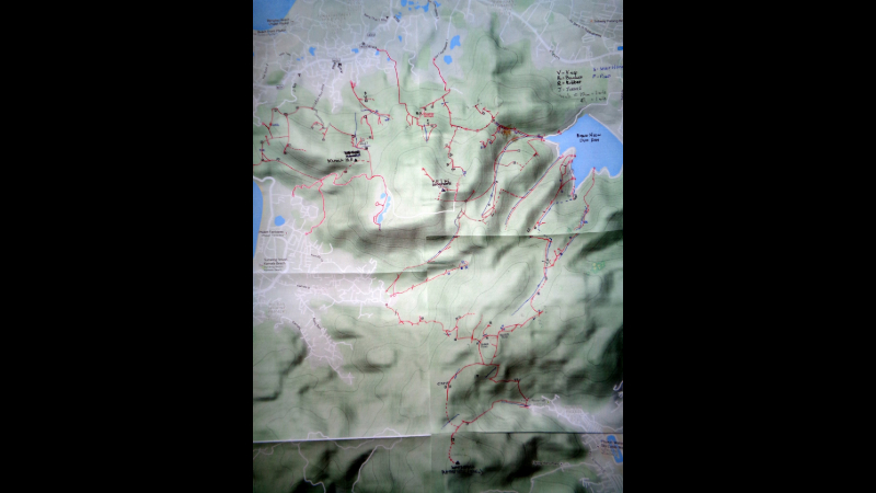
With no Ordnance Survey-style map available, he resorted to tracking each walk using the MyTrails app on his phone and transposing it onto a hard copy map (second photo above). The comprehensive, circuitous route pictured is the result of around 400 hours of shorter walks across approximately 220 kilometres over six years. It’s also the result of a great deal of trial and error.
“Typically, trails split. You’ll go left one day, right the next day. Some are dead ends,” Tony explains. “Some trails are very easy to follow as they’ve been concreted over to help the hill farmers travel up and down on their motorbikes. Others are not so good.”
The dotted lines pictured are the not-so-good trails, some of which Tony has forged himself, machete in hand, in order to join up two disparate trails.
Tony has experience of laying trails for the Hash House Harriers – the non-competitive running social club, initially founded by expats in post-war Malaysia and now run worldwide – in Aberdeen as well as the Indonesian cities of Medan and Jakarta. In fact, he helped start up Phuket’s Tinmen Hash.
While these experiences have undoubtedly proved useful in this process, Tony insists that any relatively fit adult could do what he has done, and he encourages them to, safely.
Apart from the occasional friendly farmer who invites him in for coffee, Tony has only ever crossed paths with one foreign couple, who were studying the flora and fauna, and two Thai men.
“I met the Thai guys right in the middle of a really difficult bit. We were walking through this tall elephant grass, about 6ft high. It was a very, very faint trail. I heard this rustling in front of me. I thought it was an animal. Then I heard someone talking Thai but they hadn’t heard me. We were both shocked to see each other!”
On his under-canopy escapades, Tony is much more likely to come into contact with: all number of species of spiders – some larger than a hand and in webs spanning 6ft – cobras, gibbons, lizards, millipedes and butterflies, shrines and spirit houses, streams, waterfalls, mangles and presses for rubber, enormous buttress roots and, oddly enough, model dinosaurs that decorate a Patong zip line route.
While it is difficult to provide readers with a definitive description of the routes, Tony recommends Bang Neow Dum reservoir as a starting point. Many of the more established trails are visible from this point, winding up into the hills.
Naturally, walkers should take the necessary precautions such as carrying food and water, information for navigation, satellite devices with spare battery packs, a phone with emergency contacts and informing someone of when and where they will be walking.
Even after six years mapping these trails, Tony can still find himself challenged by the jungle.
“Only last week, as I was walking to the highest point in Phuket with my friend Nick Emerson, a fellow Brit who has helped me plot many trails, we tried to get from one trail to another but it was very steep and the forest was too dense,” he says. “I knew the other trail was right there but we couldn’t get through. You win some, you lose some.”
But, like many things in life, walking the Phuket hills is about the journey, not the destination.
Tony welcomes suggestions for how his walks can be comprehensively mapped and easily shared. He can be contacted at tsgiles01@gmail.com