


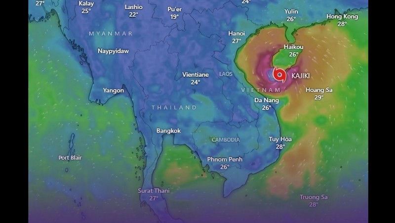
The storm is forecast to bring damaging winds and widespread flooding to areas including Thanh Hoa, Quang Tri, Hue and Da Nang, reports the National News Bureau of Thailand with flights cancelled and boats ordered to stay in port.
Kajiki is currently generating sustained winds of 166 km/h (103 mph) and is expected to intensify further before moving inland. The typhoon is already affecting southern China, where Hainan is experiencing strong winds and heavy rain. China’s weather agency has forecast up to 320 millimeters (12.6 inches) of rain in the area.
In Vietnam, authorities have advised residents in the storm’s path to stay indoors since yesterday afternoon. Officials reported that Kajiki could weaken after landfall, but may still deliver winds up to 200 km/h and rainfall between 300 and 400mm. Coastal regions are bracing for storm surges between 2 and 4 meters (6.6 to 13 feet).
Vietnam Airlines has cancelled at least 22 flights scheduled for yesterday and today. Soldiers have been deployed to assist with evacuations and to prepare affected communities for potential damage.
Officials fear Kajiki could match the destruction caused by Typhoon Yagi in September last year, which killed hundreds across the region, including 300 people in Vietnam. Emergency measures remain in place as the storm moves closer to land.
The Bangkok Post reports that Typhoon Kajiki will weaken into a low pressure system and reach the northern Thai province of Nan tomorrow evening, according to the Meteorological Department.
The weather conditions will be highly likely in provinces along the path of the storm. They are Bung Kan, Chiang Mai, Chiang Rai, Lampang, Lamphun, Loei, Mae Hong Son, Nakhon Phanom, Nan, Nong Bua Lam Phu, Nong Khai, Phayao, Phrae, Sakon Nakhon, Udon Thani and Uttaradit.
The storm will have indirect impacts on the East and the western side of the South.