


“During this period right now there are cold air masses coming from the South China Sea spreading over Phuket, which creates the northeast monsoon,” said Roongrawee Aonkot, Director of Southern Meteorological Center (West Coast).
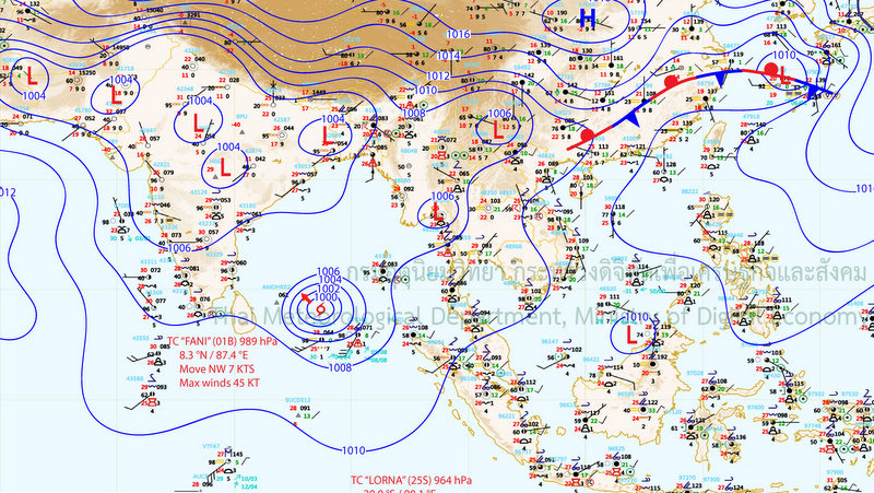
“But at the same there is Cyclone Fani in the Bay of Bengal, which is not affecting Phuket directly, but it is causing winds from the southwest to head our way,” she told The Phuket News.
“Because we now have winds blowing from both directions, that is causing air to lift right over us. Add in the hot weather Phuket has been having and you the result is altogether is heavy downpours,” Ms Roongrawee explained.
“If we didn’t have wind coming from the two directions, we wouldn’t have this rain. It would just be a fair breeze,” she noted.
Phuket being stuck in between the two weather systems began on Friday, Ms Roongrawee explained.
“It will not last long. I expect the dual-wind conditions to weaken and disappear within this week, leaving us with the normal southwest monsoon,” she said.
In the deluges on Saturday, Phuket Airport recorded 45.2mm in 24 hours, but the Phuket Town area recorded 78.4mm of rainfall, mostly within a three-hour period. (See here.)
As Phuket enters the southwest monsoon season, when the winds whip up dangerous surf along the west coast and strong storms blow in, Ms Roongrawee revealed that the Thai Meteorological Department weather radar for Phuket is operational after months being offline due to maintenance and repairs.
“The weather radar for Phuket was shut down while we carried renovations. It is working again and live online in the TMD website (see here), but it is still only 90% up and running. We will have back to 100% again soon,” Ms Roongrawee said.